Saturday, July 29, 2006

East Africa and Uganda Protectorates STAMP


EAST AFRICA AND UGANDA PROTECTORATES, AF
The territory in East Africa which was formerly administered by the British East Africa Colony, and is now divided as Kenya Colony and the Uganda Protectorate
From: Scott's Standard Postage Stamp Catalogue
1938, Ninety-fourth Edition

Wednesday, July 26, 2006

KENYA - UGANDA Stamps


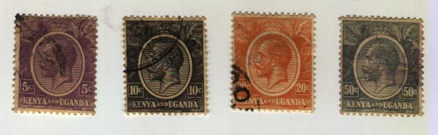
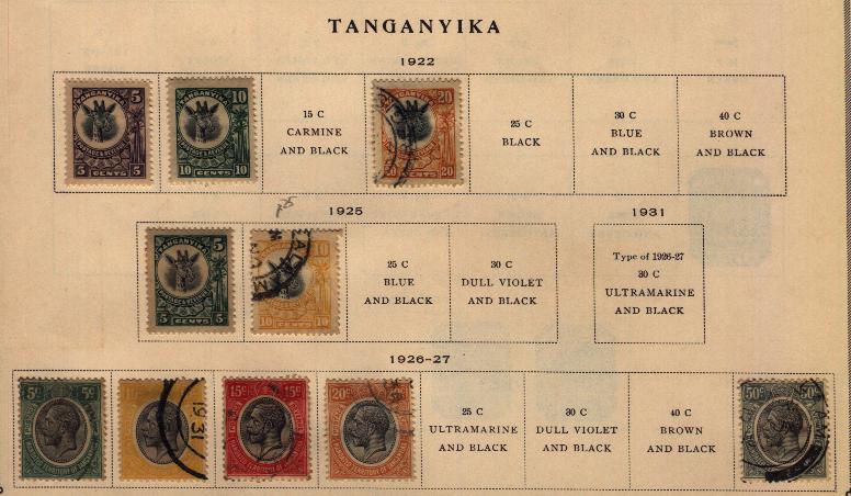
KENYA and UGANDA, AF
(Formerly East Africa and Uganda Protectorates)

A British Colony and Protectorate in East Africa lying north of Tanganyika and bordering on the Indian Ocean. Kenya, a Crown Colony since 1906, includes the former East Africa Protectorate which included a strip of land, ten miles wide, extending along the coast to the northern branch of the Tana River, belonging to and leased from the Sultan of Zanzibar. With the formation of Kenya Colony from the East African Protectorate, this strip of land was proclaimed the Kenya Protectorate and is still leased from the sultan. A section of the northern portion of Kenya, west of the Juba River, was ceded to Italy in 1925. The Area of Kenya Colony is 245,000 square miles (including the territory owned by the Sultan of Zanzibar). The inland Uganda Protectorate, lying west of Kenya Colony, is the former kingdom of Uganda. It was declared a British Protectorate in 1894 and includes the present Kingdom of Uganda. The Protectorate is 94,200 square miles in area. The capital of the colony is Nairobi, and of the Protectorate, Entebbe. The monetary unit is the east African shilling which is divided into one hundred cents. The normal value of the shilling is twenty to the British pound.
From: Scott's Standard Postage Stamp Catalogue
1934 Ninety-fourth Edition

Sunday, July 16, 2006

Early SIERRA LEONE Stamps


Sierrra Leone
Stamps from 1884-93


SIERRA LEONE, AF.

A British Colony and Protectorate on the west coast of Africa, lying between French Guinea and Liberia. The country originated in 1788 when a native king sold to English settlers a piece of land intended as a home for natives of Africa who were waifs in London. The colony proper extends along the coast and inland from 8 to 20 miles and has an area of 4,000 square miles. The Protectorate extends inland about 180 miles and is about 27,000 square miles in area. The whole represents an area comparable with the State of Maine. Capital, Freetown.
From: Scott's Standard Posatage Stamp Catalogue
1938 Ninety-fourth Edition

Early CEYLON Stamps


1872-85 stamp


1886-93 stamp set

CEYLON, A.

A British Crown Colony consisting of an island in the Indian Ocean separated from India by the Gulf of Manaar. Area is 25,332 square miles or about as large as the combined area of the Staes of Massacusetts, New Hampshire and Vermont, Caoital Colombo, Monetary unit, the rupee (15 rupees = 1 pound).

From: Scott's Standard Postage Stamp Catalogue
1938 Ninety-fourth Edition

Saturday, July 15, 2006

Early TANGANYIKA Stamps


TANGANYIKA
Stamps from 1922 / 1925 / 1926-27


TANGANYIKA, AF.

A territory in southeast Africa, bordering on the Indian Ocean, which since the World War has been mandated to Great Britain. Prior to the war this area formed part of the German East African colony.

In 1935 special postage stamps for Tanganyika were seperseded with a series used jointly by Kenya, Uganda and Tanganyika.
From: Scott's Standard Postage Stamp Catalogue
1938, Ninety-fourth Edition

Tuesday, July 11, 2006

GOLD COAST STAMPS


GOLD COAST, AF.

A British Colony and Protectorate on the west coast of Africa, bordering on the Gulf of Guinea, and lying between the French Colonies of Dahomey and Ivory Coast. Was discovered by Portuguese navigators in the 14th Century and was exploited by British and Dutch traders in the 17th Century, principally engaged in slave traffic. Was ceded to Great Britain by convention in 1871. The area of the Colony, including the the Protectorate, is about 93,000 square miles. Ashanti and the Northern Territory are also attached to the Colony and for administrative purposes the colony includes the mandated territory of Togoland. West African currency is in use.

From: Scott's Standard Postage Stamp Catalogue
1938, Ninety-fourth Edition

Early Stamps from GOLD COAST. 1884-91 / 1898 / 1902 / 1907-11

Monday, July 10, 2006

STAMPS from TRANSVAAL


TRANSVAAL, AF.
(Formerly So. African Republic)
A former Crown Colony of Great Britain which today is an inland province of the Union of South Africa. Was known as the South African Republic until 1877, when it was occupied by the British. The republic was restored in 1884 and in 1900 the country was annexed to Great Britain and called "The Transvaal". Joined the Union of South Africa in 1910. Area, 110,500 square miles, which is comparable with the area of the Stateof Nevada. Capital, Pretoria.


from: Scott's Standard Postage Stamp Catalogue
1938, Ninety-fourth Edition


Stamps from Transvaal 1885-93 / 1902-09

Thursday, July 06, 2006

ORANGE RIVER COLONY STAMP


ORANGE RIVER COLONY, AF
(Orange Free State)

One of the former self-governing British colonies located in South Africa which in 1910, joined together to form the present Union of South Africa, a self-governing Dominion of the British Empire. Stamps of the Union have been in use since 1910.

from: Scott's Standard Postage Stamp Catalogue
1938, Ninety-fourth Edition


1868-1900 Een penny stamp

Tuesday, July 04, 2006

angelas FDCs

Please visit http://angelas-fdcs.blogspot.com (pls see our link) for a gallery of our collection of First Day Covers (FDCs).

Fourth of July (1996) FDCs


July 4 is Philippine American Friendship Day.
These First Day Covers (FDCs) were issued in 1996 for the 50th Anniversary.
In 1946, July 4 however, was once celebrated as Philippine Independence Day.

Two different PhP 4.00 stamps and a Souvenir Sheet are on the FDCs.

FOURTH of JULY (1951 and 1956)


Celebrating the 5th and 10th Anniversary of the Republic of the Philippines

FOURTH of JULY (1949) Postal Card


Postal Card, stamped July 4, 1947
Third Anniversary of the Philippine Republic.

Fourth of July (1948) FDCs


July 4, 1948
Second Anniversary
Republic of the Philippines
First Day Covers
6c and 12c stamp values

FOURTH of JULY (1947) Stamps on FDC


July 4, 1947
Republic of the Philippines
First Anniversary

Stamps feature President Roxas taking oath

FOURTH of JULY (1946) Stamps on FDC


Issued on July 4, 1946. Back when the Fourth of July was celebrated as Philippine Independence Day (Inauguration of the Republic of the Philippines). Today, July 4 is commemorated in the Philippines as Philippine-American Friendship Day.

* The stamps are the first republic stamps.

Saturday, July 01, 2006

USA BICENTENNIAL Overprints


For the Fourth Of July
1976 American Revolution, Bicentennial
PhP 1.09 Christianization imperf souvenir sheet of of 1965 ovpt by GPO.
75s black surch. S/S (air) : 270,000
75s red surch. S/S : 130,000